
Surveying expertise for development, construction, and property decisions across New Zealand.
ACE Surveyor is a director-led surveying practice based in Auckland, supporting homeowners, architects, builders, and developers across New Zealand.

Get in touch
021 198 7679
1A/25 Airborne Road, Rosedale, Auckland 0632
info@acesurveyor.com
Topographic Survey in New Zealand: What It Includes and When You Need One

by ACE Surveyor
A topographic survey is often the first technical step in a development project, yet it is also one of the most commonly misunderstood.
In New Zealand, a well-prepared topographic survey provides the base information required for architectural design, planning assessments and engineering coordination. Getting it right early can significantly reduce redesign, RFIs and approval delays later in the project.
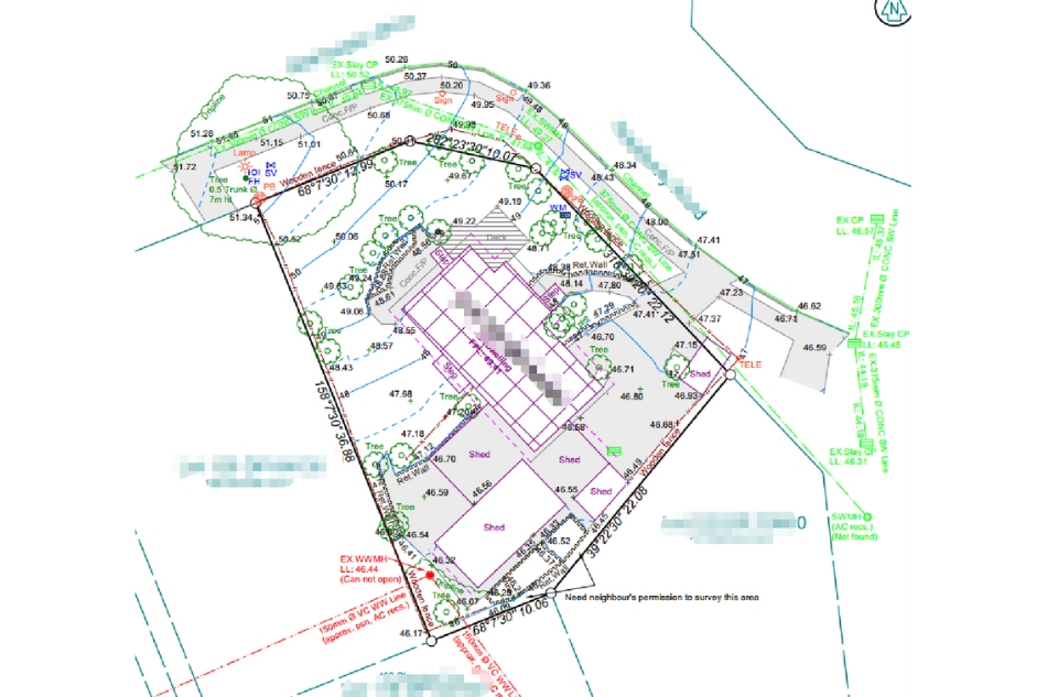
What is a Topographic Survey?
A topographic survey records the existing physical features of a site, including:
- Ground levels and contours
- Buildings and structures
- Boundary fences and walls
- Driveways, crossings and hardstand areas
- Services features (where visible)
- Trees and vegetation
- Adjacent features affecting the site
The survey is typically prepared in a format suitable for resource consent or building consent design, allowing consultants to work from a reliable, coordinated base.
When Is a Detail & Contour Survey Required?
In New Zealand, topographic surveys are commonly required for:
- Resource consent and building consent submissions
- Residential infill and dual occupancies
- Medium-density developments
- Boundary clarification prior to design
- Early feasibility and yield studies
Even for smaller projects, relying on outdated or incomplete survey information often leads to design changes once council or certifiers review the documentation.
What Makes a Survey "Fit for Purpose"?
Not all surveys are created equal. A fit-for-purpose survey should:
- Match the intended approval pathway (resource consent vs building consent)
- Reflect current site conditions
- Be prepared at an appropriate accuracy level
- Clearly communicate constraints relevant to design and planning
Early engagement with a surveyor helps ensure the survey scope aligns with how the information will actually be used.
Final Thoughts
A topographic survey is not just a drawing, it is the foundation for every design and approval decision that follows.
Clear scope definition and accurate site data from the outset help projects progress smoothly through design and approvals, reducing avoidable delays.